


FRIENDSVILLE 11 Voting District, Wabash County, Illinois
About
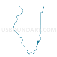
Outline

Summary
| Unique Area Identifier | 575074 |
| Name | FRIENDSVILLE 11 Voting District |
| County | Wabash County |
| State | Illinois |
| Area (square miles) | 27.98 |
| Land Area (square miles) | 27.97 |
| Water Area (square miles) | 0.01 |
| % of Land Area | 99.96 |
| % of Water Area | 0.04 |
| Latitude of the Internal Point | 38.51622710 |
| Longtitude of the Internal Point | -87.80806450 |
Maps


Graphs
Select a template below for downloading or customizing gragh for FRIENDSVILLE 11 Voting District, Wabash County, Illinois


Neighbors
Neighoring Voting District (by Name) Neighboring Voting District on the Map
- LANCASTER 12 Voting District, Wabash County, IL
- LICK PRAIRIE 13 Voting District, Wabash County, IL
- LUKIN 24 Voting District, Lawrence County, IL
- MT CARMEL 8 Voting District, Wabash County, IL
- WABASH 10 Voting District, Wabash County, IL
Top 10 Neighboring County Subdivision (by Population) Neighboring County Subdivision on the Map
- Mount Carmel precinct, Wabash County, IL (8,389)
- Wabash precinct, Wabash County, IL (1,007)
- Lancaster precinct, Wabash County, IL (559)
- Friendsville precinct, Wabash County, IL (550)
- Lukin township, Lawrence County, IL (429)
- Lick Prairie precinct, Wabash County, IL (213)
Top 10 Neighboring Unified School District (by Population) Neighboring Unified School District on the Map
- Wabash Community Unit School District 348, IL (10,927)
- Red Hill Community Unit School District 10, IL (8,629)
- Allendale Community Consolidated School District 17, IL (1,020)